CLEVELAND — Back to warm coats and Winter-like weather to start the week.
A cold low pressure and trough will rotate through the Great Lakes tonight. Lows will drop into the lower and middle 30s. Scattered areas of snow, perhaps mixing with rain near the lake shore, will will rotate around the low and into Northern Ohio tonight. Snow totals will be minimal in most spots. East in the snowbelt, we could see some accumulating snow in spots by sunrise to the tune of 1 to 3 inches.
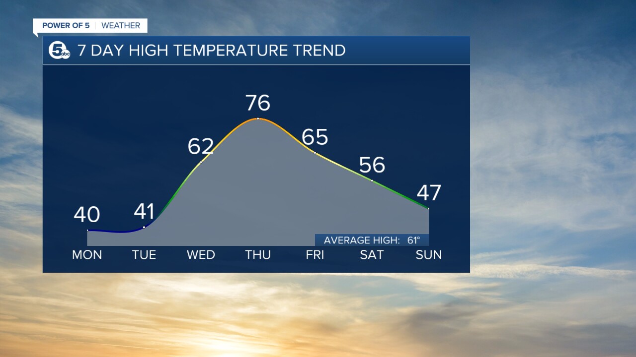
Some scattered snow mixing with rain could continue Tuesday morning east of Cleveland in the snowbelt. Elsewhere, A brief morning sprinkle of flurry will lead to a few peaks of cold afternoon sunshine. Highs on Tuesday will only reach back into the 40s.
We will see more seasonal temperatures return on Wednesday, along with some sunshine. Thursday, temperatures will then bump back up to near 80 degrees, along with a late-day storm chance returning.
More rain and cooler air will be with us as we wrap up the work week, as temperatures drop into the low to mid 60s Friday. Highs will fall into the low to mid 50s this weekend, with slight chances for rain once again.
What To Expect:
- Scattered snow tonight
- Much colder tonight
- Morning flakes and drops on Tuesday
- Tuesday highs in the 40s
- Back to 60 on Wednesday
- Near 80 on Thursday
- 70 degrees and rain on Friday
- Cooler weekend
Daily Breakdown:
Monday Night: Scattered snow, a dusting for most. Breezy. | Low: 33º
Tuesday: A few rain/snow showers. Breezy. | High: 47º
Wednesday: Partly sunny. Seasonal. | High: 65º
Thursday: PM storms. Warmer. | High: 80º
Friday: Rain showers. Thunder. Cooler. | High: 71º
Saturday: Scattered rain showers. Cooler Again. | High: 58º
Download the News 5 app for the latest weather updates:
Follow the News 5 Weather Team:
Mark Johnson: Facebook & Twitter
Trent Magill: Facebook & Twitter
Katie McGraw: Facebook & Twitter
Phil Sakal: Facebook & Twitter


